The Study Area and Route Options
The study area and route options
The study area is the geographical area where we propose to install the electricity infrastructure for Powering Up Dublin. Our studies concluded that we need to replace the underground cables linking the following substations:
- North Wall and Poolbeg
- Finglas and North Wall
- Carrickmines and Poolbeg
- Two cables linking Inchicore and Poolbeg
How we identify route options
We follow a set of guidelines called routing principles when we are identifying route options. Our routing principles for this project, where possible, are to:
- Avoid motorways;
- maximise the use of national, regional and local roads;
- avoid going through private land or agricultural lands;
- avoid sensitive natural and built heritage locations;
- minimise impact on local communities where possible.
We also consider constraints. Examples of constraints are:
- The width and quality of the road;
- other utilities in the area such as water, gas and drainage;
- City and County Development Plans and Local Area Plans;
- areas of high amenity and ongoing works;
- impact on the environment including European and national protected areas for biodiversity, invasive and protected species and other important biodiversity areas (including undesignated habitats).
In addition to this, feedback from local communities is at the heart of our process.We also collaborate with local authorities, transport operators and utility providers to identify opportunities to coordinate construction activities and minimise disruption. Emerging Best Performing Route Options.
Emerging Best Performing Route Options
 We have identified twelve potential underground cable route options:
- North Wall and Poolbeg (three options)
- Finglas and North Wall (three options)
- Carrickmines and Poolbeg (three options)
- Two cables linking Inchicore and Poolbeg (three options)
How we identified the Emerging Best Performing Routes
These routes were assessed against a number of criteria including: technical, economic, environmental, socio-economic and deliverability. These studies are available on our website. We will continue to carry out studies to determine if they are suitable. These twelve routes are called the Emerging Best Performing Routes.
The project team collected all data available and analysed each potential route looking at many different criteria. This allows the project team to select study areas for the routes which are the best opportunity based on the information available.
Due to the volume of underground infrastructure and people within the city, we are now engaging with stakeholders before we start surveying and site investigations to see if the underground cable routes proposed are viable.
We outline the installation process in this site.
After we do site investigations on these routes and engage with local communities and residents, the routes may change slightly due to:
- utilities in the ground;
- conditions;
- disruption to communities.
Routes may interconnect
Route options may intersect with each other. This means we may progress part of one route and join it with another route. This is partly due to our road network being heavily congested as it moves towards the inner city.
We will then select the routes and present the Best Performing Route Options.
At times, we may not be able continue a certain portion of the works. However, our site investigations should limit this once we have chosen a viable route.
We will then select the routes and present the Best Performing Route Options.
This map outlines the twelve Emerging Best Performing Route Options.
Once we review your feedback and carry out site investigations we will determine the five Best Performing Route Options.
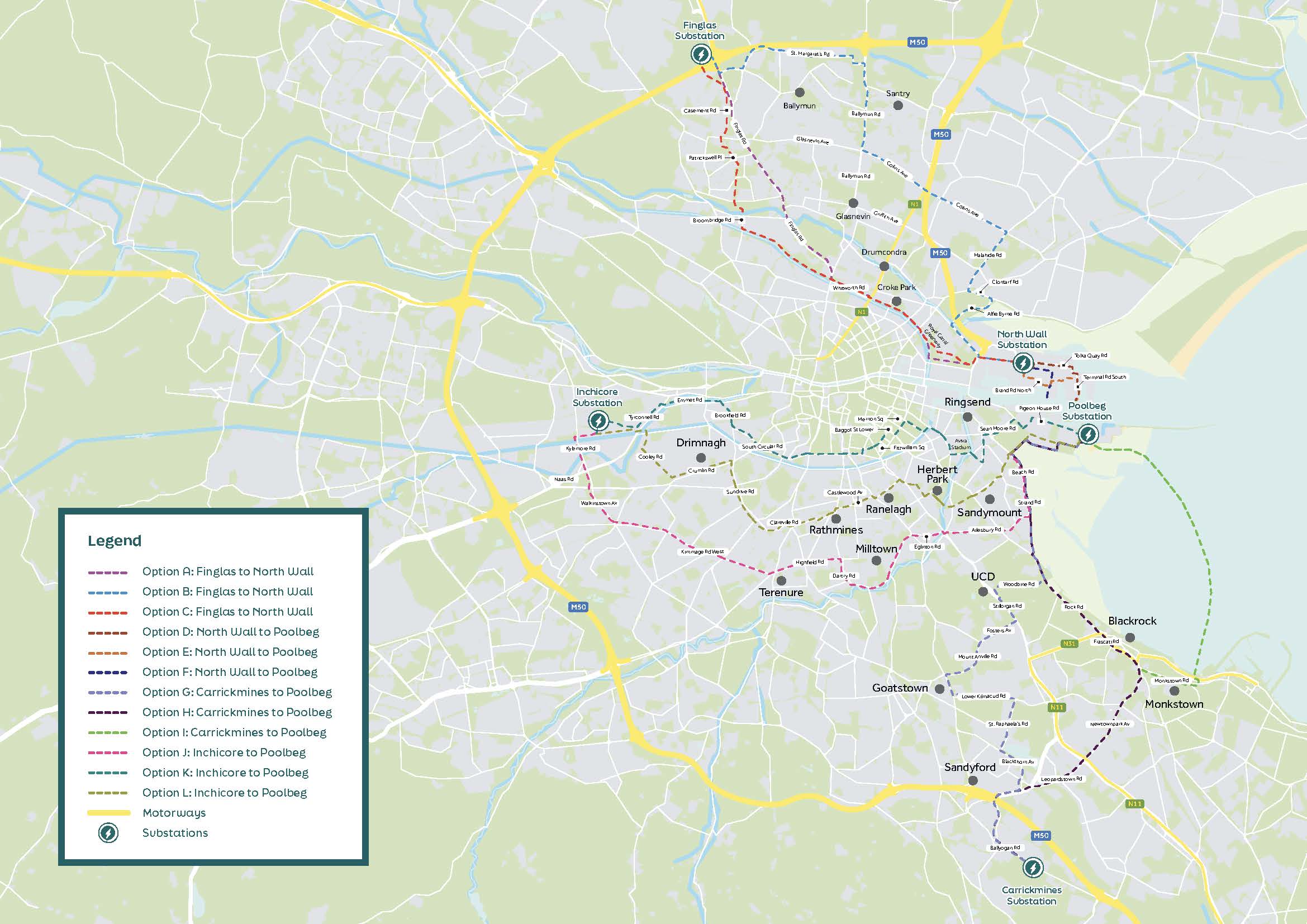
Click to zoom and enlarge
Interactive map of route options
At a glance view of the proposed route options
The following table provides an overview of the twelve underground options we are considering for this project.
Please note that the route lengths referenced below are indicative only and will be finalised when a full and detailed route is agreed.
|
Option |
Estimated overall length (km) |
Estimated off-road sections (km) |
Environmental impact |
Social impact |
Key points |
|
A: Finglas to North Wall |
10.8 |
4 |
Low-Medium |
Medium |
Service tunnels or Horizontal Directional Drilling (HDD) under M50 Tolka River bridge Railway and canal crossing |
|
B: Finglas to North Wall |
13.8 |
0 |
Low-Medium |
Medium |
Service tunnels or HDD under M50 Alfie Byrne bridge Railway and canal crossing |
|
C: Finglas to North Wall |
14.1 |
8 |
Low-Medium |
Medium |
Horizontal Directional Drilling (HDD) under M50 Tolka River crossing below via HDD Tolka Valley Park Railway and canal crossing |
|
D: North Wall to Poolbeg |
3.1 |
0.9 |
Low-Medium |
Low-Medium |
HDD likely under Alexandra Road. River Liffey Crossing Adjacent to the Dublin Docks proposed natural heritage area. High utility congestion in Pigeon House Road. |
|
E: North Wall to Poolbeg |
3.2 |
2.3 |
Medium |
Low-Medium |
Large sections of this route are on private land (Dublin Port Company owned land) River Liffey Crossing. Adjacent to the Dublin Docks proposed natural heritage areas. High utility congestion in Pigeon House Road. |
|
F: North Wall to Poolbeg |
2.7 |
0.4 |
Low-Medium |
Low-Medium |
HDD likely under Alexandra Road. River Liffey Crossing Sections of this route are on private land (Dublin Port Company) High utility congestion in Pigeon House Road. Site |
|
G: Carrickmines to Poolbeg |
15.4 |
1.9 |
Low-Medium |
Medium |
M50 crossing Luas crossing DART crossing onto Strand Road at Merrion gates. Crossing through Sean Moore Park and Irishtown Nature Park, High utility congestion on Poolbeg peninsula |
|
H: Carrickmines to Poolbeg |
14.2 |
1.9 |
Low-Medium |
Medium |
M50 crossing Luas crossing DART crossing onto Strand Road at Merrion gates. Crossing through Sean Moore Park and Irishtown Nature Park, High utility congestion on Poolbeg peninsula |
|
I: Carrickmines to Poolbeg |
14.9 |
6.4 |
Low-Medium |
Medium |
M50 crossing. Space for landfall on Poolbeg Peninsula and Salthill and Monkstown Submarine cable across Bay |
|
J: Inchicore to Poolbeg |
15.7 |
2.5 |
Medium |
Medium |
Grand Canal crossing at Kylemore Road. Luas Red Line crossing under the Naas Road. DART crossing at Sydney Parade |
|
K: Inchicore to Poolbeg |
13.5 |
3 |
Low-Medium |
Medium
|
DART Crossing on Lansdowne Road. Proximity to Aviva Stadium. River Dodder crossing |
|
L: Inchicore to Poolbeg |
13.5 |
3 |
Low-Medium |
Medium |
Grand Canal crossing at Tyrconnell Road. Luas Red Line crossing at Tyrconnell Road. River Dodder crossing at Ballsbridge. DART Crossing on Serpentine Avenue LUAS Green Line crossing Grand Canal crossing |