This project is very welcome and I acknowledge the valuable information that has been provided during this engagement process. The maps and constraints report have been particularly helpful as has...
The Study Area and Route Options
Closed31 Aug, 2021, 12:01am - 22 Nov, 2021, 11:59pm
The study area and route options
The study area is the proposed geographical area within which the electricity infrastructure for The Kildare-Meath Grid Upgrade is proposed to be built. This study area has been revised since Step 3 to reflect the further studies we have carried out in Step 4 and the route options we have identified. Figure 3 displays the study area using a red dashed line. Within this, there are 4 route options: Red, Green, Orange and Blue.
How do we plan route options?
We follow a set of guidelines called routing principles when we are identifying route options. Our routing principles for this project, where possible, are to:
- Avoid motorways;
- Maximise the use of national, regional and local roads;
- Avoid town centres and industrial estates;
- Avoid going off-road, through private land and through agricultural land where possible;
- Avoid sensitive natural and built heritage locations;
- Minimise impact on communities where possible; and
- Minimise the overall length of the route.
We also consider constraints. Examples of constraints are:
- The width and quality of the road;
- Other services in the road such as water, gas and drainage;
- Impact on the environment including European and national protected areas for biodiversity, invasive and protected species and other important biodiversity areas(including undesignated habitats);
- City and County Development Plans and Local Area Plans; and
- Areas of high amenity and ongoing works.
In addition to this, feedback from local communities is at the heart of our process.
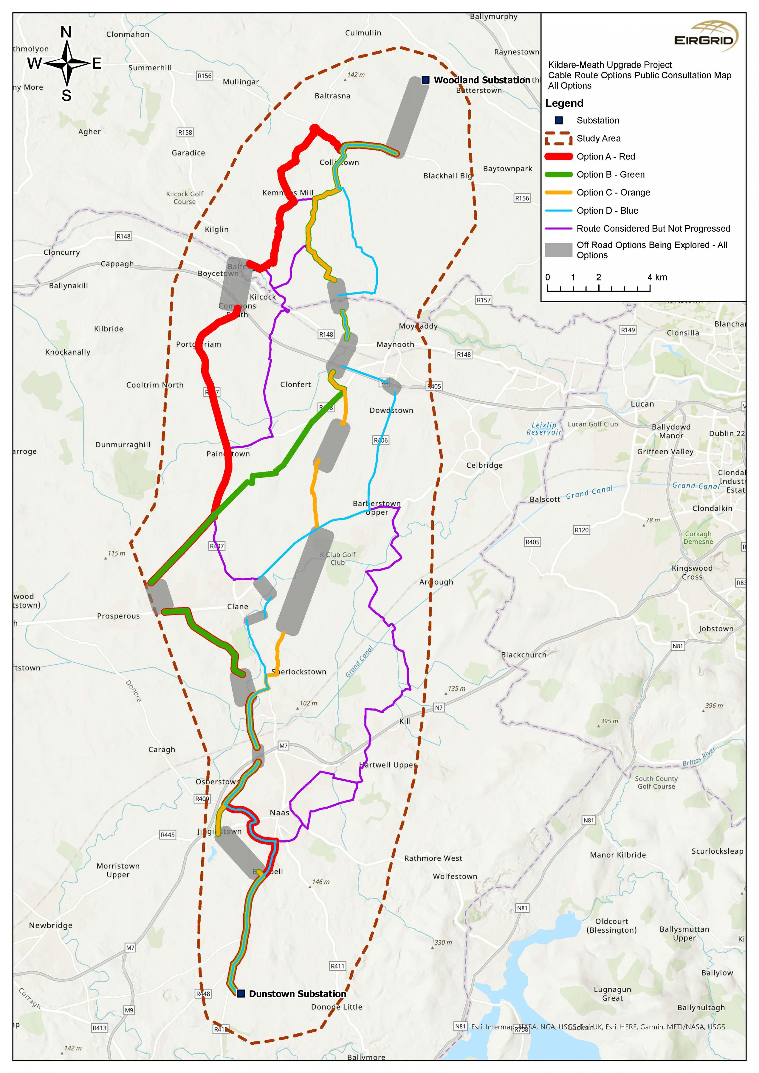
Figure 3: The study area and route options
Click to enlarge and zoom
Interactive Map
Common to all four route options
Woodland Station – all routes start here
All the shortlisted options have a common route section at Woodland station in Co. Meath. Further local consultation, surveys, design and assessment are required before we can determine a more specific route in this area. We will avoid impacts to homes, community facilities and business. We will avoid agricultural land as far as possible by carefully routing the cable and discussing it with the people affected.
Dunstown Station – all routes travel here
South of Naas, all potential routes connect with the R448 (Kilcullen Road) and travel south past Killashee. All routes meet the road junction of R412 and then travel into the Dunstown substation.
Royal Canal and Grand Canal crossings – all routes cross here
All route options will need to cross the Royal Canal and Grand Canal. Both are proposed Natural Heritage Areas (pNHAs); designated for a variety of wetland habitats and species. It is proposed that the cable will be drilled under these by trenchless construction methods to avoid any physical impact. Please know that we will engage extensively with all relevant bodies, carry out all necessary studies and put in place all risk mitigations prior to commencing these works.
Common infrastructure and watercourse crossings
All our route options will need to cross some or all of the following:
Watercourses:
- the Rye Water,
- River Liffey.
Infrastructure:
- Dublin-Sligo railway line,
- Dublin-Cork (and others) railway line,
- the M4 motorway,
- the M4 motorway,
- the N7 national road and
- the M7 motorway.
We propose that the cable be drilled under these watercourses and infrastructure. We will use trenchless construction methods to avoid any physical impact.
Please know that we will engage extensively with all relevant bodies, carry out all necessary studies and put in place all risk mitigations before starting these works.
The lengths of the 4 options range from 47km to 51km. Most of the cable route in each option can be laid in the existing road network. However, each option will require some of the cable route to be off-road. These off-road corridors will range from 5km to 12km of the cable route. Where off-road routing is unavoidable, we do not yet know what the exact route may be. For this reason, we highlight a corridor of space on the route maps. The off-road section may pass through this corridor. We will determine this after discussing it with the landowners affected. We will avoid agricultural land as far as possible by carefully routing the cable.
Please note that we could consider further route options by combining sections of the proposed routes. Additional adjustments may emerge from the consultation process if you, the public, identify additional information for consideration.
At a glance view of the proposed route options
The following table provides an overview of the four underground cable options we are considering for this project.
Please note that the route lengths referenced below are indicative only and will be finalised when a full and detailed route is agreed.
| Option | Estimated overall length (km) | Estimated off-road sections (km) | Environmental impact | Social impact and potential disruption during construction | Meets technical requirements |
Other notable points |
|---|---|---|---|---|---|---|
| Option A (Red) | 51 | 5 | Low | Low-moderate | Yes | Travels to the west of Kilcock village, longest route, but it affects the least amount of agricultural land of all options. |
|
Option B (Green) |
50 | 8 | Low-moderate | Moderate-high | Yes | Travels through Rathcoffey and Moortown. |
| Option C (Orange) | 47 | 13 | Low-moderate | Moderate-high | Yes | Shortest cable but it affects the most agricultural land of all options |
| Option D (Blue) | 51 | 6 | Low | Low-moderate | Yes |
Table 1: At a glance comparison of the proposed route options
In the following sections, we look at each of the four options in turn.
Contents
Observations
Observations
County Meath Chamber welcomes the advancement of the Kildare Meath Network upgrade and the ongoing process to select an underground option for the project. This upgrade is crucial to the social and...
My ranked preference in order of priority (1 = best, 4 = not desired) for the options are:
1. Option C Orange
2. Option B Green
3. Option A Red
4. Option D Bue
RPS is instructed by Venturis Investment Group (hereafter Venturis) to submit this observation with regard to the proposed Kildare Meath Grid Upgrade Consultation. Venturis own a site of c. 88ha at...
The routing principles might be appropriate for underground powerlines in other parts of the country, but they appear inappropriate for a routing spanning the immediate commuter belt around Dublin...