I have no comments. Provided the facility is underground.
Option C - The Orange Option
Closed31 Aug, 2021, 12:01am - 22 Nov, 2021, 11:59pm
Option C - The Orange Option
Option C is potentially the shortest of the four options, however it will potentially cross more agricultural land than the other options.
From Woodland. Option C is proposed to travel south along the L1012 (Mulhussey Road).
To the south of the Southern Link Business Park, a potential off-road corridor crossing agricultural land is shown. This section of Option C will cross:
- the Grand Canal.
Option C connects with the R448 (Kilcullen Road) and then travels into the Dunstown substation.
The route will pass the Mulhussey National School (St Josephs).
The route travels west and passes the roadside Mulhussey Castle and Cemetery toward Kiltens Gap Crossroads.
The route travels south towards Rodenstown and then south east to Bryanstown. A potential off-road corridor is shown where Option C will travel south to cross:
- the Rye Water, and
- agricultural land.
A potential off-road corridor is shown where the cable will cross:
- the Royal Canal,
- the River Lyreen
- the Dublin-Sligo railway line, and
- the M4 Motorway, avoiding Laraghbryam Cemetery.
A potential off-road corridor is shown where Option C will cross agricultural land. It will then connect with a local road in the townland of Smithtown, travelling south thorough Johninstown and Ovidstown, crossing:
- the R403 to the north of the K Club.
A potential off-road corridor is shown travelling to the south until the townland of Blackhall. Here it travels under local roads, past the now closed Bodenstown Golf Club, and the roadside Bodenstown Cemetery, before connecting the R407.
Option C will travel along the R407 for a short length before connecting to the new Sallins Bypass.
Along the Sallins Bypass, Option C will cross:
- the River Liffey twice,
- Dublin-Cork (and others) railway line, and
- the Grand Canal, and
- the M7 Motorway (potential off-road corridor).
Under the M7 Motorway, Option C will then travel along the Millennium Link Road, travelling to the west around Naas.
To the south of the Southern Link Business Park, a potential off-road corridor over agricultural land is shown.
Option C connects with the R448 (Kilcullen Road) and then travels into the Dunstown substation.
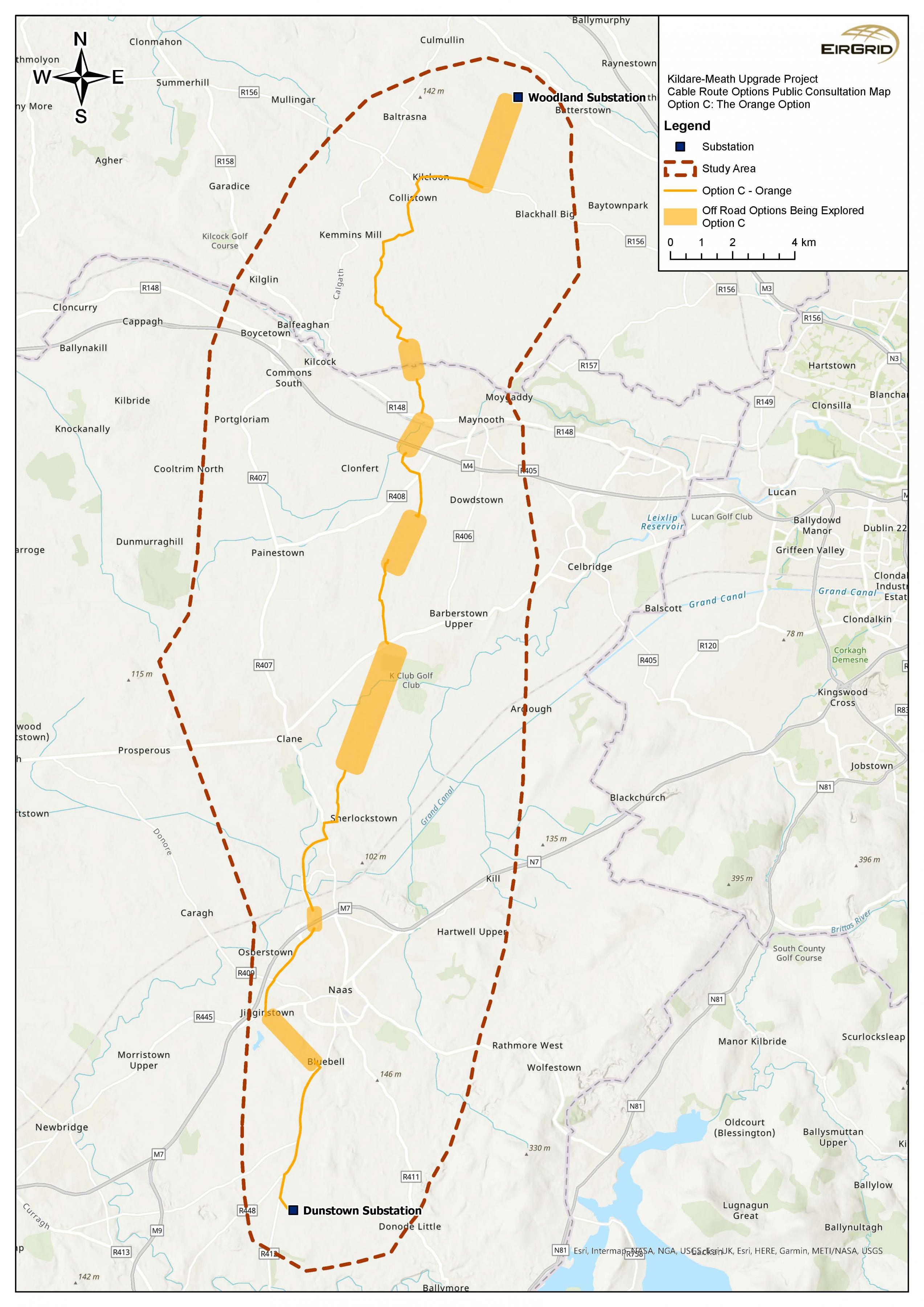
Figure 6: Option C: The Orange Option
Click to enlarge and zoom
Interactive Map: Option C - The Orange Option
Contents
Observations
Observations
Least favoured - most impact agriculturally, socially & environmentally.
Recommended option to minimise traffic disruption, Consultation with farmers on timing in relation to crops. Minimise ingress to maximum