This option passes by [Redacted: Personal Information] on a narrow country road with no hard shoulder and ditches either side. I’m concerned about how access will be maintained. I’m concerned about...
Option C - The Yellow Option
Closed7 Sep, 2022, 9:00am - 30 Nov, 2022, 11:59pm
Option C - The Yellow Option
Option C is the longest of the cable route options at 43km but has the shortest off-road section, with 2 km off-road. Option C affects the least amount of agricultural land of the four shortlisted options.
Option C shares the initial 2km route out of Woodland substation with Option B. A potential off-road corridor is shown for this. Upon joining the L2215, Option C will progress north to Batterstown. Here the route may pass off-road and so a potential off-road corridor is shown. South of Batterstown it will travel along the R154 to the M3 motorway.
Option C will cross the River Tolka, then move off-road to cross the M3 Motorway to the south of the M3 Southern Toll Plaza, returning to the roadway at the roundabout to join the R147. A potential off-road corridor is shown for this motorway crossing. The route will then travel south along the R147 until the L5026 Pace, travelling east, with the more direct minor road through the townland of Kinoristown preferred to the minor road further south, through Rowan.
Option C will continue N town and into Kilbride. In Kilbride, it will pass Kilbride National School and progress south along the Kilbride Road. This route will enter Hollystown, turning northeast to join the R121 before reaching Hollywoodrath.
A potential off-road corridor is shown for the M2 motorway crossing. Following this, the route returns to the R121 and follows it through the Ward Cross until it finishes at the R122. Here, Option C will move southeast, using Kilreesk Lane and then following Kilreesk Road, Cooks Road and north into Forest Road. It will run along Forest Road next to Forrest Little Golf Club and into the southern suburbs of Swords, where the L2300 and R132 are used to return south to Cloghran Roundabout.
Option C will then follow Stockhole Lane, crossing the M1. A potential off-road corridor is shown for this motorway crossing. The proposed route option will then return to Stockhole Lane and turn east onto Baskin Lane which it will follow to the junction with the Malahide Road in Kinsealy. It will then move south, past Fingal Burial Ground, returning west along the R139 before turning north along the access road to reach Belcamp substation.
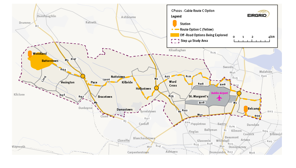
Figure 7: Option C: The Yellow Option
Click to enlarge and zoom
Interactive Map: Option C - The Yellow Option
Contents
Materials
Observations
Observations
Dear Sir/Madam
This is a submission on behalf of St, Margarets The Ward Residents Group. This Group represents the Residents of The St Margarets and The Ward Communities. The attached...
Not Route C. Re Route, Batterstown always has disturbance due to work at Woodlands.